
Introduction
Vehicle GPS follows the vehicle, not the person. It is different from staff tracking, which uses the technician's phone (see Fleet and GPS tracking): the vehicle sends its position even if nobody has the app open, and the technician's position goes with them even when they leave the vehicle.
| Concept | What it is |
|---|---|
| Device | The vehicle's GPS, identified by its IMEI or by the number its platform gives it. It is installed in one vehicle and can be moved to another |
| Fleet platform | A tracking service the customer already pays for (Geotab, Movertis, Webfleet or Frotcom). Maptainer queries it automatically |
| Rate | How many seconds apart a position is stored for each vehicle. Your Maptainer provider sets it |
| Last position | Where the vehicle is now, whether it is moving and since when |
| Track | The stored positions of a vehicle, joined in a line on the map |
Positions arrive in one of three ways. One customer can use several at once:
| Way | For whom | What to do |
|---|---|---|
| Own device | Whoever buys the GPS (Teltonika, Concox, Queclink…) with its SIM card | Configure the device with Maptainer's address and register it with its IMEI |
| Fleet platform | Whoever already has Geotab, Movertis, Webfleet or Frotcom | Connect the platform with its API credentials and match its vehicles |
| Sent via API | An integrator or another platform that sends the positions to Maptainer | An API key with the Vehicle positions permission |
Prerequisites
Modules
Vehicle GPS is included in the Fleet control module: with it subscribed you can already register devices or connect a fleet platform, without subscribing to anything else. Vehicles, their assignments and the alerts come from the same module. The rate is set by your Maptainer provider (see Position rate). The contracted modules are shown in General Settings, as explained in Tenant administration.
| Screen or feature | What is needed |
|---|---|
| Vehicles map layer and Today’s track | Fleet control |
| GPS tab in Vehicles | Fleet control |
| Vehicle GPS alerts block in the Alerts tab | Fleet control |
| Assigning a vehicle to a team | Fleet control, with teams in use |
Permissions
Permissions are managed in Roles and Permissions, under Contracted Modules. Roles are explained in Tenant administration.
| Group and permission | What it allows |
|---|---|
| Fleet control: vehicle GPS · View | The Vehicles layer, a vehicle's track and the GPS tab (devices and settings, without changing them) |
| Fleet control: vehicle GPS · Manage | New device, installing or removing it from a vehicle, Connect a platform, Match vehicles and Save settings |
| Fleet Control · View | Opening the Vehicles menu |
| Notices · Fleet | Receiving vehicle GPS alerts in the bell |
The Administrator has everything. Give Fleet control: vehicle GPS to any role that needs it, together with Fleet Control · View.
Setting up an own device
An own device sends its positions straight to the Maptainer server. Maptainer understands the Teltonika, Concox (GT06) and Queclink protocols.
- In the administrator, click Vehicles, in the Fleet group, and open the GPS tab.
- Copy the address for your brand from the How positions arrive box: the server and the port for Teltonika, GT06 / Concox or Queclink.
- Configure the device with that address. This is done with the manufacturer's tool (Teltonika Configurator, for example) or by SMS, as its manual explains.
- Click New device. In Source, leave Own device (Teltonika, Concox, Queclink…).
- Type the IMEI or identifier: the 15-digit IMEI on the device label.
- Type a Name (optional), for example the model, and choose the vehicle in Installed in.
- Click Register.
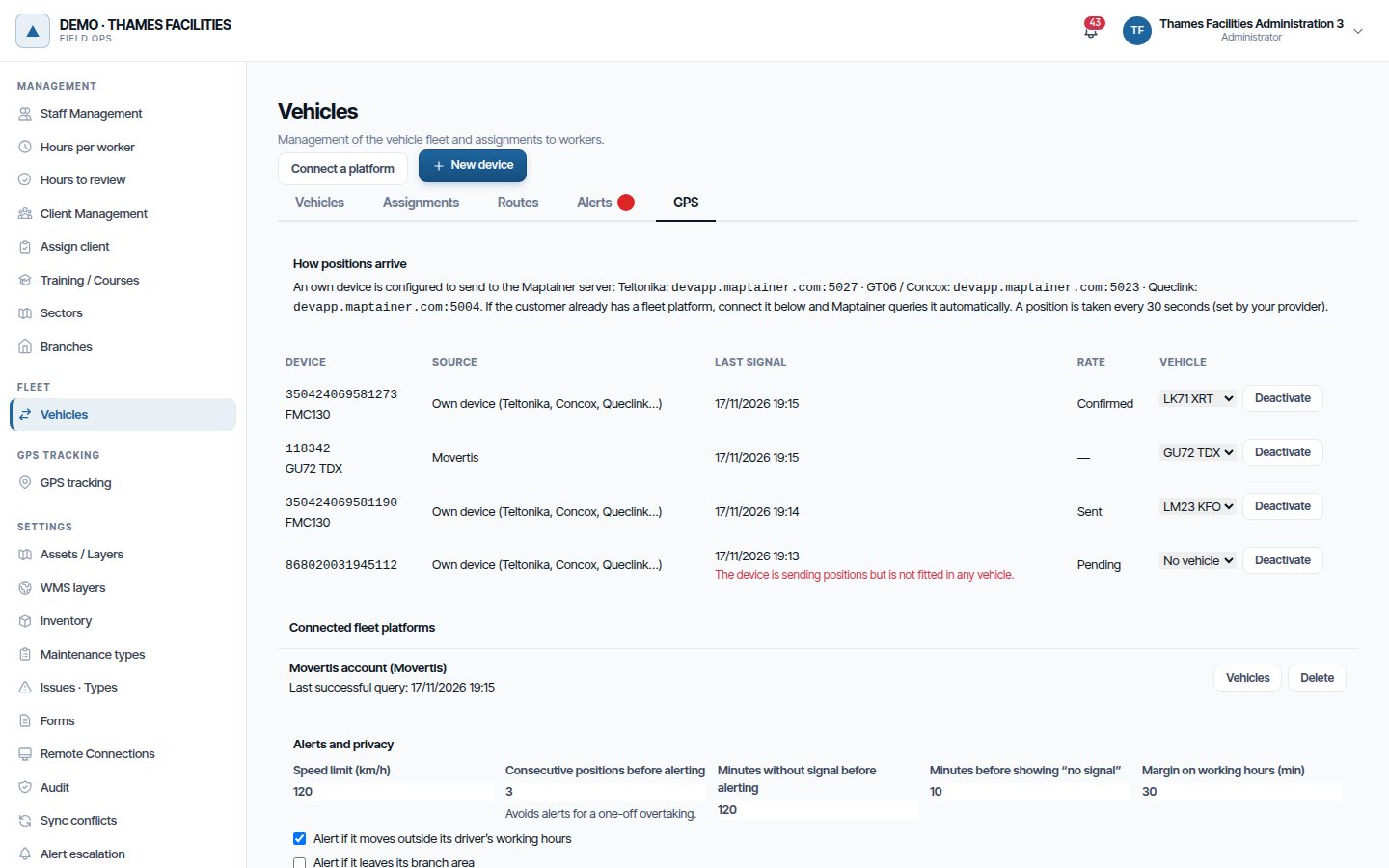
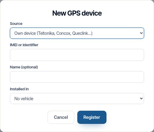
As soon as the device has coverage, Last signal shows the time of its last position and the vehicle appears on the map. When it is registered, Maptainer sends it the rate; the Rate column says whether it has received it:
| Rate | What it means |
|---|---|
| Pending | It could not be sent yet. It is retried every minute while the device is connected |
| Sent | The order has been sent. Devices that connect only now and then receive it on their next connection |
| Confirmed | The device has replied that it applies it |
| Not supported | Its protocol does not allow the rate to be changed remotely. Configure it on the device itself |
| Failed | The device rejected the order. Check its configuration |
Even if a device does not obey, Maptainer stores at most one position per vehicle in each rate interval. Engine starts, stops and positions over the speed limit are always stored as well.
Note
An IMEI that is not registered in Maptainer is discarded: nothing from it is stored. Register the device before configuring it or right after.
Moving a device to another vehicle
In the device list, choose the new vehicle in the drop-down on its row. The change applies from that moment: earlier positions stay with the vehicle that had it. Choose No vehicle to remove it.
A device that sends positions without being installed in any vehicle is shown in red with the message “The device is sending positions but is not fitted in any vehicle.”. Its positions are not stored until you install it.
Deactivate stops storing its positions and removes it from its vehicle. Use it for a faulty or retired GPS. Activate brings it back, but you have to install it in a vehicle again.
Connecting a fleet platform
If the customer already has its vehicles in Geotab, Movertis, Webfleet or Frotcom, no other GPS is needed: Maptainer queries the platform every minute with its API credentials.
- In the GPS tab, click Connect a platform.
- Choose the Platform and change the Name if you want to tell several accounts apart.
- Fill in the credentials. Each platform asks for its own:
| Platform | What it asks for | Where to get it |
|---|---|---|
| Geotab | Server, Database, User and Password | A MyGeotab user with API access. The database is the company name in MyGeotab |
| Movertis | Server and API token | Movertis support provides the token. The API is a separate paid service |
| Webfleet | Account, User, Password and Webfleet API key | A WEBFLEET.connect user and the API key provided by Webfleet |
| Frotcom | User and Password | A Frotcom user with API access |
- With Movertis and Frotcom, Also fetch the track between queries stores every position in the minute, not just the last one. With Frotcom it makes one request per vehicle: keep it for small fleets.
- Click Connect. Maptainer starts querying it within a minute.
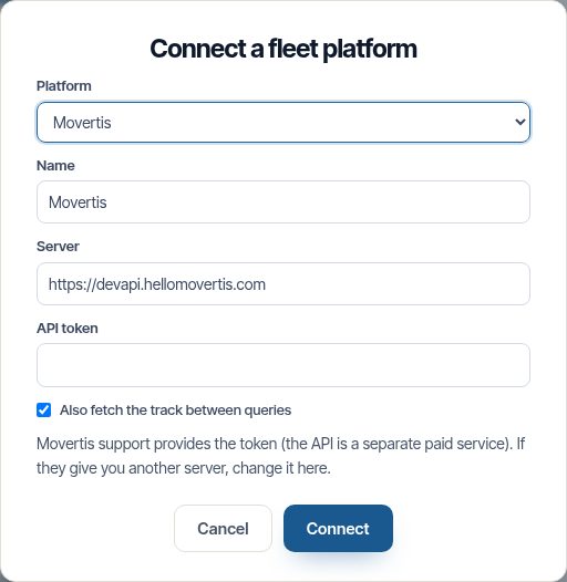
The password, token and key are stored encrypted and are not shown again. To change them, delete the connection and create it again.
Matching the platform's vehicles
The platform has its own list of vehicles. You have to say which one each is in Maptainer:
- In Connected fleet platforms, click Vehicles on the connection.
- For each platform vehicle, choose the Maptainer vehicle. Leave No vehicle for the ones you do not want to follow, such as a trailer.
- Click Save. Each matched vehicle is registered as a device, with the platform as its source, and appears in the device list.
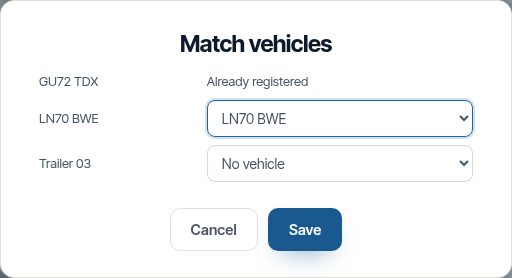
Those already registered show Already registered. If the platform adds vehicles, click Vehicles again to match the new ones.
Under each connection you see Last successful query or, if it fails, the error in red. If the platform rejects the credentials, Maptainer waits an hour before trying again. If it does not respond or asks to wait, it tries again the next minute.
Sending positions via the API
For an integrator or a platform that is not included to send the positions:
- Register each device with New device and Source Sent via API. The identifier is the one the integrator will use for each vehicle.
- In API and data backups, create a key with the Vehicle positions permission (see Create an API key).
- Give the key to the integrator. The call is
POST /fleet/positions, with up to 200 positions per request and 600 requests per minute. It is described in API reference.
Each position carries the device identifier, the time with its time zone, the longitude and the latitude. Speed, heading, ignition and odometer are optional. The response says how many were stored and why each of the others was rejected.
Seeing vehicles on the map
- On the map, open the layers panel.
- Tick Vehicles (live GPS). The first time, the map zooms to the fleet.
- Click a vehicle to see its card.
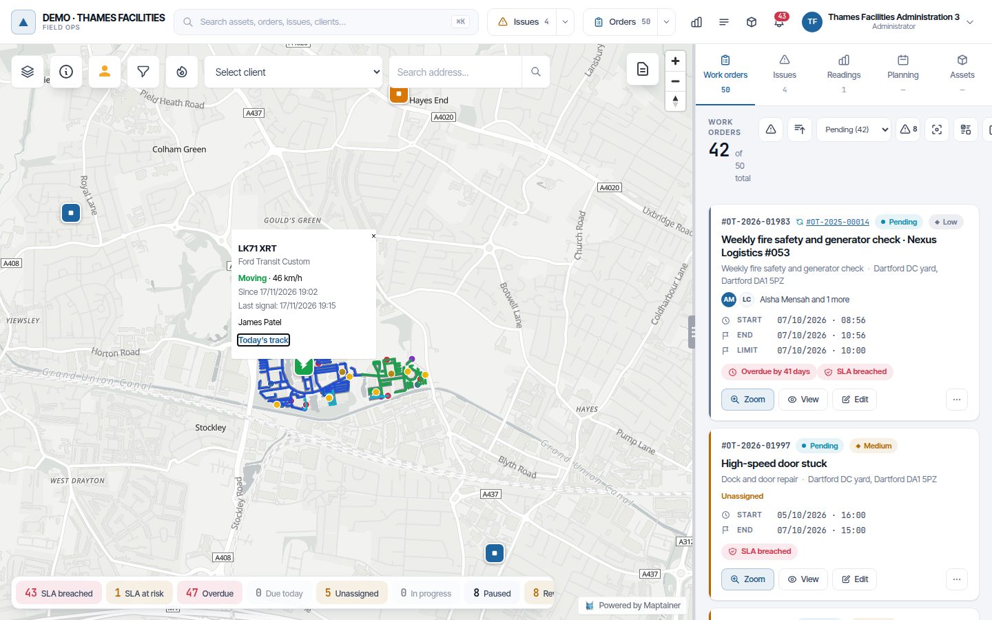
| Colour | Meaning |
|---|---|
| Green, with an arrow | Moving. The arrow points where it is heading |
| Blue | Stopped |
| Amber | No signal: its last position is older than Minutes before showing “no signal” (10 by default) |
The card shows the plate, make and model, the state with the speed, Since when it has been moving or stopped, the Last signal and who has it, with their work order in progress if they have one (click the code to open it). If the vehicle belongs to a team, each member's name appears with the team in brackets.
The vehicle icon carries the initials of whoever is inside (two at most, with a “+” if there are more).
The layer refreshes itself every 30 seconds while it is ticked and the browser tab is in view.
Warning
With the recommended privacy option, outside the shift of whoever has the vehicle the card says No visible driver. The vehicle is still shown and its position is stored, but it is not linked to the person (see Alerts and privacy).
One symbol per person
With the Vehicles and GPS positions layers ticked at the same time, a technician who is inside their vehicle is not drawn separately. They count as inside if:
- the vehicle is the one assigned to them (their own or their team's);
- both have sent a recent signal: their phone in the last 15 minutes, and the vehicle is not in amber;
- they are 150 m apart or less.
When they get out at the WO and move away, their dot appears again. With the Vehicles layer unticked, staff are shown as usual.
Today’s track
On a vehicle's card, click Today’s track. Its track since 00:00 is drawn in blue and the map zooms to it.
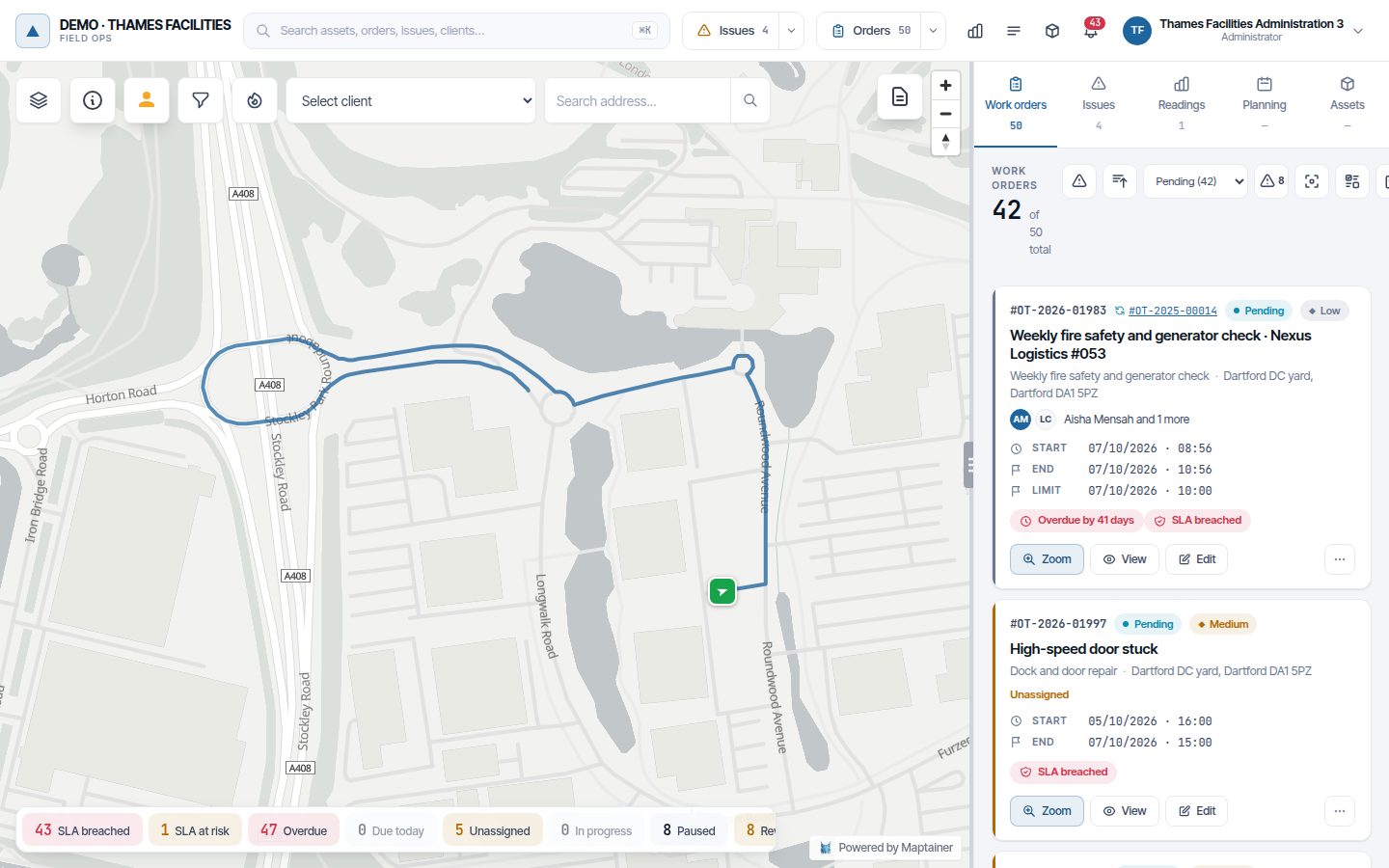
- The track stays on the map until you ask for another vehicle's or untick the layer.
- If the vehicle has no positions today, “… has no track today.” appears.
- A track of more than 10,000 positions is cut off, with a message.
- Every track lookup is recorded in Audit, with who looked at it and for which vehicle.
Note
This track is also what gives the actual km of the trips of whoever drives the vehicle: in the Routes tab they carry the Vehicle GPS label (see Fleet and GPS tracking).
The odometer
With GPS, the vehicle's odometer is kept by the GPS and trips no longer add km to it. Not every unit reads it the same way:
| What the unit sends | What Maptainer does | Label in Vehicles |
|---|---|---|
| The vehicle's odometer (connected to its on-board computer) or its platform's | Uses it, counting on from the figure the vehicle had | GPS |
| An odometer calculated from the positions (Frotcom's, or the one the server calculates if the device sends none) | Uses it in the same way. If the unit's own arrives later, it switches to it with no jumps | Calculated GPS |
| None (some platforms, such as Geotab today) | Adds the daily km of its track while moving | GPS route |
- The first reading does not change the figure: many units count from installation, and Maptainer carries on from the odometer the vehicle already had.
- If the device restarts and counts again from a low figure, the odometer does not go back.
- If you correct it by hand in Edit, the GPS keeps counting from the new figure.
- If the device sends no signal for more than 48 hours, the odometer goes back to advancing with the trips until it returns.
The dashboard fleet summary, by vehicle, compares the GPS km with the trip km: the difference is the Unallocated km (see Fleet and GPS tracking).
Trips from the vehicle stops
If a worker is not using phone tracking, the geofence does not see when they arrive at their WOs and their trips are not created. With this setting they are deduced from their vehicle's stops:
- A stop is the vehicle standing still for at least Minutes stopped to count as a stop (5 by default).
- It counts for whoever had it assigned, if they were within their working hours.
- It must be less than Maximum distance to the work order (m) (250 by default) from one of their WOs that is not cancelled.
- With those visits, the outward trip from their base, the trips between WOs and the return are created, as the geofence would do, with the km from the vehicle GPS.
- It never changes the status of any WO: it only provides km and cost.
- It only looks at finished days in the last three, and each person and day once.
- It does nothing if that day the person had phone positions, geofence crossings or already has trips.
- In Routes, these trips carry the mark “Deduced from the vehicle stops”.
It is enabled in Alerts and privacy, with Create the trips from the vehicle stops when the operator is not using phone tracking. It is off by default.
Assigning a vehicle to a team
A crew travelling together in a van has the vehicle as a team, not person by person. That way every member has their vehicle and the journey is not counted twice.
- Open Vehicles → Assignments and click Manual assignment.
- In Assign to, choose A team.
- Choose the Team and the Vehicle, set Active from and, if you want, Active until. Times are those of the team's branch.
- Click Create assignment.
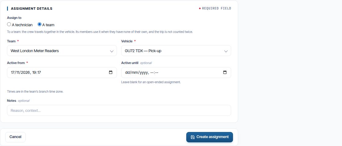
Assign to only appears if the company uses teams. In the assignment list, team assignments carry the Team label next to the name.
| Situation | Which vehicle each member has |
|---|---|
| They only have the team's | The team's, while they are a member |
| They also have one assigned to them | Their own: a personal assignment takes precedence over the team's |
| They leave the team | They stop having it from that moment, without changing the assignment |
| Two members arrive together at the same work order | One member's trip carries the vehicle, fuel and kilometres; the other's does not. They count as travelling together if they arrive less than 20 minutes apart |
In the Planning User View, the vehicle a member has through their team shows the team's name and cannot be changed from there: change it in Assignments.
A vehicle can only be assigned to one person or one team at a time. To release an assignment before its end, click End now on its row: what has already been done stays with that vehicle.
Alerts and privacy
The settings are at the bottom of the GPS tab, in Alerts and privacy. Change them and click Save settings.
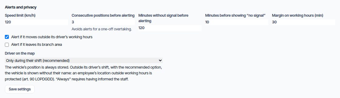
| Setting | What it does | Default |
|---|---|---|
| Speed limit (km/h) | Above it, the position counts as speeding | 120 |
| Consecutive positions before alerting | How many positions in a row over the limit are needed to alert. Avoids alerts for an overtaking manoeuvre | 3 |
| Minutes without signal before alerting | Time without positions from an installed device before alerting | 120 |
| Minutes before showing “no signal” | From when the vehicle shows in amber on the map | 10 |
| Margin on working hours (min) | Tolerance before and after working hours for the out-of-hours alert | 30 |
| Alert if it moves outside its driver’s working hours | Turns the out-of-hours alert on | Yes |
| Alert if it leaves its branch area | Turns the out-of-area alert on | No |
| Alert if it is moving and the phone of whoever drives it is far away | Turns the Without its driver alert on. Staff tracking is also required | Yes |
| Distance to the phone of the driver (km) | From what distance the phone counts as far away | 1 |
| Minutes away before alerting | The phone must be far away now and also these minutes earlier | 10 |
| Create the trips from the vehicle stops… | See Trips from the vehicle stops | No |
| Minutes stopped to count as a stop | For trips from stops | 5 |
| Maximum distance to the work order (m) | For trips from stops | 250 |
| Driver on the map | Only during their shift (recommended) or Always | Only during their shift |
The alerts
Alerts appear in the bell for whoever has Notices · Fleet and in Vehicles → Alerts, in the Vehicle GPS alerts block. Each vehicle has at most one open alert of each type.
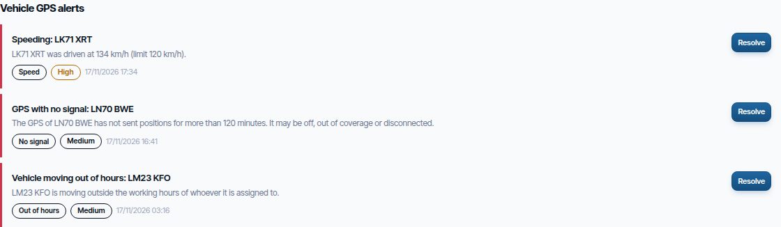
| Alert | When it fires | When it closes |
|---|---|---|
| Speed | The vehicle exceeds the speed limit for the set number of consecutive positions. If it happens again while the alert is open, it is updated with the top speed and the number of times | When you click Resolve |
| Out of hours | The vehicle moves or has the ignition on outside the shift of whoever has it, plus the margin. With nobody assigned, its branch's working hours count. The alert does not say who had it | When you click Resolve, or by itself when that person's off-shift activity for that day is regularised (see Fleet and GPS tracking) |
| No signal | An installed device has gone more than the set minutes without sending positions. Checked every 10 minutes. A device that has never sent anything does not alert | By itself, when the signal returns |
| Out of area | The vehicle leaves its branch's polygon | By itself, when it comes back into the area |
| Without its driver | The vehicle is moving and the phone of whoever has it assigned is further than the set distance, now and the set minutes earlier: another driver or unauthorised use. It does not fire without phone positions. Staff tracking is required | By itself, when the phone is next to the vehicle again, or when you click Resolve |
Who is shown on the map
The vehicle's position is always stored. With Only during their shift (recommended), outside the working day of whoever has it the vehicle is shown without their name: locating an employee outside their working hours is protected under Spanish law (art. 90 LOPDGDD). Always asks for confirmation, because it requires the staff to have been informed beforehand.
Warning
Before fitting the devices with identifiable drivers, tell the staff that the vehicles carry GPS. The simplest way is to mention it in the Geolocation notice (see Fleet and GPS tracking).
Position rate
Your Maptainer provider sets the rate in your company's record: from 10 to 600 seconds, 30 by default. In the GPS tab it is shown in How positions arrive: “A position is taken every … seconds (set by your provider)”.
| Way | How it applies |
|---|---|
| Own device | It is sent to the device and, in addition, Maptainer stores at most one position per interval |
| Fleet platform | It is queried when due, never more than once a minute. If it brings the track, it is stored at the rate |
| Sent via API | Maptainer stores at most one position per interval |
At 30 seconds, a vehicle on the move all day leaves up to 2,880 positions; at 10, up to 8,640. Ask your provider for a shorter rate if you need finer tracks.
Monitoring
| Where | What you see |
|---|---|
| Vehicles layer | Where each vehicle is, whether it is moving and who has it |
| Today’s track | Where a vehicle has been today |
| GPS tab | The last signal of each device, whether it has received the rate and whether its platform responds |
| Alerts tab | Open speed, hours, signal and area alerts |
| Audit, Fleet GPS category | Device registrations, connections, settings and rate changes, and track lookups |
Positions are kept for 90 days. After that they are deleted automatically.
The vehicle's positions while a person was driving it, within their working hours, are that person's data: they are included in Export data in their record, together with who looked up that vehicle's track on those days (see Staff and teams). When the person is deleted they are not erased, because they belong to the vehicle; they are left with nobody to attribute them to.
Current limitations
- The track can only be requested from the map and only for the current day. There is no date picker or track export yet.
- The Geotab connector does not read the odometer: its vehicles advance with the GPS track (GPS route).
- A branch's area for the Out of area alert cannot be drawn from the administrator yet: ask support for it.
- A platform's credentials cannot be edited: delete the connection and create it again.
- Positions are only stored if they arrive less than 89 days old.
Common problems
| Symptom | Likely cause | Solution |
|---|---|---|
| The Vehicles layer and the GPS tab do not appear | The module or the permission is missing | Check the modules in General Settings and the role in Roles and Permissions → Fleet control: vehicle GPS |
| An own device shows Never under Last signal | It has no coverage or the server address is wrong | Check the address and port for its brand in How positions arrive and that the SIM has data |
| A device shows the red message that it is not installed | It sends positions but has no vehicle | Choose its vehicle in the drop-down on its row |
| Rate stays at Pending | The device is not connected right now | It is sent automatically when it connects. If it stays like that with a recent signal, contact support |
| A platform shows an error in red | Expired credentials or no API access | Get new credentials, delete the connection and create it again |
| A platform vehicle does not appear on the map | It is not matched | Click Vehicles on the connection and match it |
| The card says No visible driver | The vehicle is outside the shift of whoever has it, or nobody has it assigned | This is the recommended privacy. Check the assignments if it should have a driver |
| Out-of-hours alerts every day | The shift of whoever has it does not cover their real hours | Correct the shift or increase Margin on working hours (min) |
| Speeding alerts for an overtaking manoeuvre | Too few consecutive positions before alerting | Increase Consecutive positions before alerting |
| Without its driver alerts when the technician is in another van of the team | The vehicle is assigned to another person or to the wrong team | Check that day's assignments |
| A worker without a phone has no trips | Trips from stops are disabled, or their stops are not close to their WOs | Enable the setting or increase Maximum distance to the work order (m) |
Last updated: